Since my last post on this blog I have backpacked 570 miles of the Pacific Crest Trail, hiked the dusty, donkey laden hills of Reche Canyon near Colton CA, and moved to Running Springs CA at elevation 6,200 feet where I'm thoroughly enjoying the cooler weather and discovering new trails to hike every week.
I have tons of photos of where I've been, and some day -- some day -- I'll post them here along with what I was doing, maybe even some postings from my trail journal.
In the meantime, check out my new blog at RolinBrunoAuthor.blogspot.com where I'm premiering my new series of books!
You can also follow my publishing activities at facebook.com/AuthorRolinBruno, and my other activities at facebook.com/rolinbruno.
Saturday, August 29, 2015
Saturday, January 26, 2013
The Gabrielino Trail... and Return
Here are some photos from my 43-mile, 21-day circumnavigation of Mount Wilson: the long way around.
This was my "shakedown cruise," final preparation for my trip up the Pacific Crest Trail: Mexico to Canada.

The first public campground is Spruce Grove, neat and well-maintained. There was a bit of hiker traffic on this first day of the new year, most of them taking a loop route or headed for the summit of Mount Wilson.
 I shared the campground that night with one couple. The overnight low was a temperate 30 degrees.
 Just uptrail from Spruce Grove is Sturtevant Camp, the last hike-in resort still operating since the Great Hiking Era of 1895-1935. It is now owned by the Presbyterian Church, which maintains a website for the camp and accepts reservations. They have their own water system and are supplied by pack train.

After two nights at Spruce Grove I left with a mostly full pack, and was faced with the climb over Newcomb Pass. I arrived at my destination at 5:00 pm, and had to set up camp and cook dinner in the dark of the evening.
 Some might call Devore a primitive camp, for although it has picnic tables and fire rings, there is no toilet, so you must come prepared to dig your own latrine. I was here two nights, and shared the camp one night with a couple who were planning to ascend Mount Wilson and to stay overnight at another camp. As I was leaving, I met J.C., a young man who had camped at Devore for over two weeks and had to be rescued because he was starving to death. He had come back to collect his stuff--that is, the little that the critters had not chewed into.
 Most nights I had been sleeping with my food in the vestibule of the tent, but here at the relatively isolated Devore it seemed advisable to hang my food from a tree.
 The next campground upriver was West Fork, in much better shape because it was accessible for maintenance via the Red Box-Rincon Fire Road. I had two days of hard, cold rain here, my first full test of my new Big Agnes Seedhouse one-man tent. It held up well and I stayed dry and warm.

 West Fork is also the junction with the Silver Moccasin National Recreation Trail, which leads up to the mountaintop campgrounds at Chilao, and connects with the Pacific Crest National Scenic Trail. I should pass the other end of Silver Moccasin when I hike through the Angeles on the Pacific Crest Trail.

 This is what it looked like outside my tent door the next morning. Morning temperature was 30 degrees, and on the second morning it warmed up to 40 degrees.
 By this time I was thoroughly enjoying myself, in spite of the heavy pack.
 On the 9-mile hike to Switzer I took a side trip to check out Hi-Hill, a former trail resort. It had been operated since 1948 by the Long Beach School District, but is now mothballed and boarded up. The extra time for this side trip was not a good idea, as it put me after dark for my arrival at Switzer.
 I also crossed "Red Box," the junction of the Angeles Crest Highway (Hwy 2) and the Mount Wilson Road. Although closed most weekdays, I did have a chance to look inside the cultural center at the junction and see some of the artifacts.

 At Switzer my maps failed me. I thought the Trail Camp was just past the picnic area, but it was yet a mile further. I spent some time flailing around in the dark looking for it. There is no sign for the Trail Camp; it's just three USFS stoves on the site of the cabin of the old Switzer trail resort. The big draw for day hikers here is Switzer Falls (below) which I found less than spectacular.

 I had previously left a GPS waypoint marker at this sign to guide me in, and as the light of day was fading, I reached within 830 feet of it. BUT I ran out of trail, needed to find a way to cross the creek, needed to navigate around the nastiest tangle of 20-foot-long downed trees you can imagine, then cross the creek again in the dark to find the camp. It took me over an hour to travel that final 830 feet. The floods that followed the famed "Station Fire" had devastated the portions of the traill that followed the canyon-bottom.
 The Bear Canyon Trail Camp is not that bad: all it lacks is a pit toilet. But having learned my lesson, I knew I wasn't going to get up out of this canyon with a heavy pack in a single day's hike, so I planned to stop an extra night at the Stone Shed, (shown below) only 3/4 of a mile ahead.
I was correct: it took me 6 hours to negotiate that 3/4 of a mile to my next GPS waypoint. But that placed me at the launch point where the trail leaves the canyon floor and would be much better hiking.

 The following day's hike put me in more familiar territory: Mount Lowe Trail Camp, one of my favorite haunts. This is the site of the former Alpine Tavern, served by the Incline funicular and the Mount Lowe Railway operated by Pacific Electric Rail from the end of the 19th century through 1938.
 Shortly after I arrived I was joined by three young men who were circumnavigating Mount Wilson as I was, but they had come up to Mount Lowe directly from Valley Forge, bypassing Red Box, Switzer, and Bear Canyon.
It was fun to swap stories, compare equipment, and generally chew the fat with these 3 intrepid men. They left for Idle Hour the next day while I stuck with my plan to stay two nights at each campground, testing out the longevity of my food supply.


 No campground on my route can match the atmosphere of the Idle Hour Trail Camp. What it lacks in amenities it makes up for with its dappled sunshine, grassy meadows, and babbling brook. Here you just feel like relaxing.

 Henninger Flats campgrounds, run by the county fire department, is the Cadillac of camps, with piped water to each campsite, running water in the restrooms, flush toilets, and free firewood, already cut.
Add to that the weather, which had warmed considerably. The nights were too nice to huddle inside an enclosure: I left the rainfly off of the tent.
Here to my surprise I met Eric from Saint James Anglican, leading a large contingent of Boy Scouts. I joined them for dinner.

 Hoegee's campground was almost as much a disappointment as Henninger was a joy. With another pair of hikers I agreed that Hoegee's was way too close to the parking lot for anything like a wilderness experience. Swarms of children chasing about the camp and hikers barging through our campsites were not what we had expected.
 But I had used up an unplanned day at Stone Shed, so I was only going to stay here one night.
The only thing left to find out was if my car was still parked where I left it 21 days ago at Chantry Flat.
It was.
Good trip.

This was my "shakedown cruise," final preparation for my trip up the Pacific Crest Trail: Mexico to Canada.
 |
| Leaving Chantry Flat |
Here I am at Chantry Flat with an insanely overweight pack, ready to hit the trail. The Gabrielino Trail begins with a mile-long plunge deep into Big Santa Anita Canyon, where it follows the creek past dozens of cabins accessible only by foot or by pack animal.
And here is the general store allied with southern California's only remaining pack station. The pack station hauls supplies into the residents of the 30-some cabins in Big Santa Anita Canyon and to Sturtevant Camp.

The first public campground is Spruce Grove, neat and well-maintained. There was a bit of hiker traffic on this first day of the new year, most of them taking a loop route or headed for the summit of Mount Wilson.


After two nights at Spruce Grove I left with a mostly full pack, and was faced with the climb over Newcomb Pass. I arrived at my destination at 5:00 pm, and had to set up camp and cook dinner in the dark of the evening.


And then there is Valley Forge, also accessible from the Fire Road, and very well appointed.
And what should I find here but - - SNOW!


And next comes Bear Canyon: awesome to behold, but a "bear" to hike.
Gabrielino Trail is closed at the Bear Canyon junction due to rock slides, so the only way to get back to my car is to go back the way I came in, or to forge on up through this canyon. I had done some day hiking in here without a pack to prepare for this, and now the time had come.
Gabrielino Trail is closed at the Bear Canyon junction due to rock slides, so the only way to get back to my car is to go back the way I came in, or to forge on up through this canyon. I had done some day hiking in here without a pack to prepare for this, and now the time had come.


I was correct: it took me 6 hours to negotiate that 3/4 of a mile to my next GPS waypoint. But that placed me at the launch point where the trail leaves the canyon floor and would be much better hiking.

 The following day's hike put me in more familiar territory: Mount Lowe Trail Camp, one of my favorite haunts. This is the site of the former Alpine Tavern, served by the Incline funicular and the Mount Lowe Railway operated by Pacific Electric Rail from the end of the 19th century through 1938.
It was fun to swap stories, compare equipment, and generally chew the fat with these 3 intrepid men. They left for Idle Hour the next day while I stuck with my plan to stay two nights at each campground, testing out the longevity of my food supply.

As a short day trip, I visited Inspiration Point, which has been rehabilitated to appear as it did
when the Alpine Tavern was still in business. Here I had Verizon signal and could check my email.
when the Alpine Tavern was still in business. Here I had Verizon signal and could check my email.


Add to that the weather, which had warmed considerably. The nights were too nice to huddle inside an enclosure: I left the rainfly off of the tent.
Here to my surprise I met Eric from Saint James Anglican, leading a large contingent of Boy Scouts. I joined them for dinner.


The only thing left to find out was if my car was still parked where I left it 21 days ago at Chantry Flat.
It was.
Good trip.

Sunday, November 11, 2012
Back to the Future: Looking toward the Pacific Crest Trail
I'm Back!
Wow. No updates to my personal blog for more than a year. (I did just update the outcome of my cousin's death--see below--but otherwise nothing here since September of 2011). Bad, bad Rolin. For a look at what I have been up to, you can consult my ministry blog (http://resurrectiongulfcoast.blogspot.com/) where I posted 2012 updates during February, May, and July. And surprise!..... I now can be found readily on Facebook (trust me, I'm the only Rolin Bruno out there), where you can spot some personal and ministry notes, along with some of my hiking and camping photos, and even maybe a snapshot or two of friends and family......and I'm hitting the trail!
At the moment, I'm in the throes of preparing for a major cross-country hike: tackling the Pacific Crest Trail, which begins at the Mexican border near the humble town of Campo, California, and ends seven miles into Canada at Manning Provincial Park in British Columbia. So far, I have purchased some nice equipment (e.g. a 17-degree-rated goosedown sleeping bag), I have identified 33 waypoints on the trail where I can resupply my food and fuel (with up to 118 miles between resupply points), and I have been doing test hiking/camping trips into the Angeles forest where I am working out how to carry enough vegetarian food to take me 118 miles. I expect the trek to take at least 8 months, and to finish before the first autumn snows of 2013......while wrapping up ministry details in Pasadena, CA.
.....for which you may consult my West Coast ministry blog, where I hope to post an update later today or early tomorrow. Some of those ministries include: **Classes for the way out from addictions to drugs, alcohol, and other habits that make our lives unmanageable, **Help for individual addicts by acting as a Sponsor to guide them through the 12-step process to recovery, **Meals in the park for those who are homeless or without food to eat, **Management of New Visions, a 10-bed Sober Living Home supportive to those maintaining their recover from addiction by using the 12-step method, and **Assistance to an evolving ministry of the Anglican Church of North America, that is, Saint Michael's in the City, headed up by the young down-home old-time preacher Fr. Charles Myers......and being Blessed by God!

I have been in particularly good health. I found a dentist I could afford (on time payments) to correct my neglected teeth, including four root canals and six crowns. I found a chiropractor who helped me find the right corrective lift to install in my left shoe (1 & 1/4 inch) to balance out my gait, especially when carrying a heavy pack. I have recovered from hip replacement surgery, although I still have some aches and pains. I HIKED THE MOUNT WHITNEY TRAIL, achieving Trail Crest at 13,600 feet where I could look down the other side of the mountain into the Sequoia National Forest. I have trimmed off much of the spare tire around my middle, although another 5-10 pound loss would be nice. And, during this next year, before I finish my Pacific Crest Trail adventure, by the Grace of God I expect to celebrate my 70th birthday.
Thank you, Jesus!
I will try to post at least one more update to this blog (maybe two) before departing on the trail. While on the trail (at the various re-supply waypoints) I may well have a chance to post an update and a photo or two on facebook. Watch for me there!Belated Family Update: Saying Goodbye
Jeannine Elliott, my cousin and the last of the Elliott Family, passed on last year. She has been interred with her mother Naomi and her father William (Bill) at Belmont Memorial Park in Fresno, California. This was accomplished with the contributions of Bruno family members and the kind cooperation of her ex-husband, Michael East. We held a graveside memorial service during September 2011 at which Bruno family members and Jeannine's friends from the Fresno area attended and shared their recollections of her life.
May she rest in peace.
May she rest in peace.
Wednesday, September 14, 2011
Psalm 103:15 Our days on earth are like grass...
This Sunday September 11 I had in my reminders a note to call my cousin Jeannine in Fresno. Jeannine has been struggling with chronic pain and an inability to cope with the vicissitudes of life.
Unfortunately, by Saturday September 10 she had already passed away. The cause of death was a gunshot wound, and the Fresno County Coroner has ruled it a suicide. She has no children and no surviving parents, so I and my siblings are the closest kin.
Although she had made arrangements for the care of her small dog Carly, all her other affairs are in disarray. I am in contact with the coroner's office.
For He knows how weak we are; he remembers that we are only dust. Our days on earth are like grass; like wildflowers, we bloom and die. The wind blows, and we are gone--as though we had never been here. But the love of the Lord remains forever with those who fear him.
MINISTRY UPDATES; HIKING AND CAMPING
Hi folks. The irregular updates for my ministry to the Least, the Last, and the Lepers has moved to my West Coast Blog (formerly my Gulf Coast Blog): http://resurrectiongulfcoast.blogspot.com/
Much has been happening, although I am way behind on my posting. Check it out!
Much has been happening, although I am way behind on my posting. Check it out!
Saturday, July 16, 2011
Summer Update: Life and Ministry in Pasadena
Howdy, folks,
Spring sprang right past me, so here's my latest doin's now that it's summer.
 MEDICAL STUFF:
While I was caring for my mom, she fell again twice and had other medical problems, so it became clear that it was no longer safe for her to be living alone. We found an excellent nursing care home just a few miles from my sister's house and she seems to have adapted well to it.
In the meantime, I went in for my Total Hip Replacement (left hip) on March 15, and from there to a rehab facility. The photo to the right is in the rehab place after I had graduated from the wheelchair to the walker, and again from the walker to the crutches.
The lovely folk at Saint James Anglican in Newport Beach kept me in prayer during surgery and recovery, and made a prayer blanket for me (shown at left) in which every knot that held it together represented a prayer for my effective operation and safe recovery. I was deeply touched.

MOVING STUFF: After a few days at my sister's house, I hit the road to Southern California via the scenic route.
This is a rare sight--the spillway at the Oroville Dam with water actually flowing from it.
For all the time that my sis has lived in nearby Paradise, the level of Lake Oroville has been so low that there was more shoreline than there was lake. The end of the boat ramp at Lime Saddle, for instance, was a hundred yards from the water. So seeing the lake full again was a memorable local sighting.

We've been going to visit Mom in the care facility regularly.
My sister visits more than once a week, and has many details to watch over for her overall care.
My brother drove down from Oregon twice to visit, which was well appreciated.
Even my daughter drove up from Southern California to see Mom. From that visit, here's my sister Lucy, my daughter Amber, and my brother-in-law Garrett.
I've made the trip back to northern California once, and I'll be back again next month to visit Mom and make it to an appointment with my surgeon for the aftercare of my hip replacement.
MINISTRY STUFF: In Pasadena, besides trying to find a place to live, I've been working with Father Charles Myers, who's launching an urban church ministry. "Saint Michael's in the City" has started up weekly services on sort of a shake-down cruise preparing for a grand opening, we trust, in the fall.
I have been preparing to teach the 12-step class, "Common Solution Recovery," which was developed by Church Army at Branson, Missouri, and which I taught for almost a year in Mississippi to homeless Hurricane Katrina survivors who were struggling with addictions. The same scourge afflicts Pasadena, and some in the addicted and recovering communities here are desperately looking for the Way Out. The class will get a big boost from the new book We Have Recovered written by Stephen Baughan, the new director of Church Army USA.
I travelled with Fr. Charles to the Anglican Men's Weekend held in the San Bernardino Mountains. This event was sponsored for years by Saint James Anglican, but this year it became hosted by the Western Diocese of the Anglican Church in North America. Our speaker was Archbishop Greg Venables, who flew up from Argentina to deliver a powerful message to almost 200 men from all across the state and country.
Here's a sampling of the men that attended. Fr. Charles is always easy to spot in a crowd, and this photo is no different: he's the one kneeling in front.
.
.
.
.
Spring sprang right past me, so here's my latest doin's now that it's summer.
 MEDICAL STUFF:
While I was caring for my mom, she fell again twice and had other medical problems, so it became clear that it was no longer safe for her to be living alone. We found an excellent nursing care home just a few miles from my sister's house and she seems to have adapted well to it.
In the meantime, I went in for my Total Hip Replacement (left hip) on March 15, and from there to a rehab facility. The photo to the right is in the rehab place after I had graduated from the wheelchair to the walker, and again from the walker to the crutches.
The lovely folk at Saint James Anglican in Newport Beach kept me in prayer during surgery and recovery, and made a prayer blanket for me (shown at left) in which every knot that held it together represented a prayer for my effective operation and safe recovery. I was deeply touched.

MOVING STUFF: After a few days at my sister's house, I hit the road to Southern California via the scenic route.
This is a rare sight--the spillway at the Oroville Dam with water actually flowing from it.
For all the time that my sis has lived in nearby Paradise, the level of Lake Oroville has been so low that there was more shoreline than there was lake. The end of the boat ramp at Lime Saddle, for instance, was a hundred yards from the water. So seeing the lake full again was a memorable local sighting.

We've been going to visit Mom in the care facility regularly.
My sister visits more than once a week, and has many details to watch over for her overall care.
My brother drove down from Oregon twice to visit, which was well appreciated.
Even my daughter drove up from Southern California to see Mom. From that visit, here's my sister Lucy, my daughter Amber, and my brother-in-law Garrett.
I've made the trip back to northern California once, and I'll be back again next month to visit Mom and make it to an appointment with my surgeon for the aftercare of my hip replacement.
MINISTRY STUFF: In Pasadena, besides trying to find a place to live, I've been working with Father Charles Myers, who's launching an urban church ministry. "Saint Michael's in the City" has started up weekly services on sort of a shake-down cruise preparing for a grand opening, we trust, in the fall.
I have been preparing to teach the 12-step class, "Common Solution Recovery," which was developed by Church Army at Branson, Missouri, and which I taught for almost a year in Mississippi to homeless Hurricane Katrina survivors who were struggling with addictions. The same scourge afflicts Pasadena, and some in the addicted and recovering communities here are desperately looking for the Way Out. The class will get a big boost from the new book We Have Recovered written by Stephen Baughan, the new director of Church Army USA.
I travelled with Fr. Charles to the Anglican Men's Weekend held in the San Bernardino Mountains. This event was sponsored for years by Saint James Anglican, but this year it became hosted by the Western Diocese of the Anglican Church in North America. Our speaker was Archbishop Greg Venables, who flew up from Argentina to deliver a powerful message to almost 200 men from all across the state and country.
Here's a sampling of the men that attended. Fr. Charles is always easy to spot in a crowd, and this photo is no different: he's the one kneeling in front.
.
 .
.
. .
.
MORE MOVING STUFF: At the men's weekend I had a lovely bed to sleep in, but in Pasadena I had not yet found affordable housing. I learned that Pasadena has the second highest rental rates in Los Angeles County, surpassed only by Santa Monica on the beach.
Here's my interim housing: the campground in Millard Canyon. This is situated right along the rushing creek, about a hundred yards from the parking lot.
I was not ready yet at this stage for prime time backpacking, so it took quite a few trips back and forth to bring in my tent, food, and cooking gear, etc.
After one false start, I found a room to rent. I'm now ensconced in student housing at William Carey International University, which rents about a third of its dorm rooms to non-students.
My room was designed for two students, but they rented it to me as a single. It's roomy enough to divide in half, using my bookshelf as a room divider.
This is my "office" area, which has a nice window I can look out of if I face to the left. I found some flowers to put on the windowsill to spruce it up a bit.
And here's my bookshelf and Biblical Reference Library with my "bedroom" behind it.
This is the payoff for lugging 500 pounds of books across the continent, and for disassembling then reassembling the lovely bookcase that was made for me in Mississippi by one of the men in our recovery program.
Included in my library is the complete Inter-Varsity Press commentary on the Bible, which I put on the bookshelf over my office desk. On the bookshelf Above my bed you can just barely see my grandfather's violin, which I someday hope to learn to play.
HIKING STUFF: But I'm still on the road to recovery from my surgery. (I'm told that full recovery will take a whole year)
My first backpacking excursion was to Sierra Saddle, a picnic spot on the trail above Millard Campground.
This photo shows some of the trees burned in the devastating Station Fire of 2009, in which 525 square miles of forest were destroyed. Millard Canyon is in the background.
But the vegetation is bouncing back.
Here are the robust plants along the side of the fire road leading up the mountain.
They are shown here at the height of the blooming season.

This was also the peak blooming season for many of the annual flowers,
I called this place "The Best Spot On The Trail."
.
.
.

On this first backpack outing, I camped here beside Sierra Saddle a few hundred feet above Pasadena.
I pitched my tent between the two pines on this ridge at center photo, with Millard Canyon on the right and Pasadena on the left.
I didn't fully deploy the rainfly on my tent because no rain was predicted and I wanted to be able to see the views from inside.
But at 4am I was awakened by heavy raindrops on the tent, and scurried to pull the rainfly into place. It continued to rain on my tent the rest of the morning. However, when I got up in the morning, all of the ground was dry except for immediately around my tent! I thought, "What is this, Gideon's fleece?"
What had happened was that the coastal fog had been rolling across the ridge all morning. The needles on the pine trees sucked the moisture out of the fog, and each needle then dripped its collected water down onto my tent as raindrops.
Below is a view of Pasadena as the evening fades into night and the city lights begin to appear.
 .
.
.
A couple weeks later I did make it farther up the trail, all the way, in fact to Mount Lowe Trail Camp (alas, no photos). It's a 3,000 foot climb and a 6-mile hike, and it took me SIX HOURS in my not-yet-recovered condition. I'm going to have to do that again and better my time.
On a later day trip I hiked up the trail that hugs the hillsides near the bottom of Millard Canyon and leads to Dawn Mine.
This is Millard Falls, a popular site which is closed because the creekside trail was destroyed by the heavy floods after the Station Fire.
It's a 40-foot waterfall, and when you can reach the bottom of it, you can stand in the pool directly under the falling water.
.
.
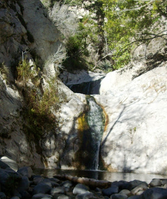
Another sight along the way to Dawn Mine is this double waterfall, high up a side canyon above the trail.
This is also visible from the upper trail which leads to Mount Lowe campground.
I have seen this spot many times, but this is the first time I've seen water in it.
.
.
.

My most recent hike (last week) was up the Arroyo Seco along the Gabrielino Trail.
This is Gould Mesa Trail Camp, just an hour-and-a-half (at my pace) up the trail.
This week I'm hoping to base camp here and try to get farther up the Gabrielino trail, perhaps all the way to Switzer Falls.

There are a number of bridges on the trail for autos, but many of them, along with the roads around them, have been destroyed by the recurring floods.
This is a more recently-constructed bridge, built to accomodate the equestrian traffic on the Gabrielino Trail.
.

"Arroyo Seco" is Spanish for "Dry Gulch," an appropriate name only for the lower reaches of the canyon after the City of Pasadena has sucked all the water out of it for its thirsty citizens.
The lower portion of the arroyo is the pathway for the nation's first freeway, now numbered Interstate 110. With its tight curves and abrupt on- and off-ramps, it is a challenging drive during rush hour.

Once above the intake point for Pasadena's water plant, the creek crossing shown at right is more typical of what will confront a hiker on the Gabrielino trail.
Some of the crossings are quite a bit more challenging than this one, especially for me as I work with strength and balance limitations on my surgery recuperation trail.
At the Gould Mesa camp, there is a road that leads off the side, climbing to meet the Angeles Crest Highway (California 2) just above the city limits of La Cañada Flintridge.
There I found this sign with a map to the local trails. (However, there was no place to park for anyone who wanted to read the sign, much less hike the trails.) Yet the sign reminded me of driving and coming across the place where the Gabrielino Trail reaches the crest of the Angeles Forest and wishing I had time to hike the trail.

So I think that's exactly what I'll do. Little by little, I'm going to see if I can reach each section of this 28.5 mile trail. Watch this space(click here) for the photos!
God bless you all,
Rolin
Subscribe to:
Posts (Atom)
